Sometimes I have to put text on a path
Showing posts with label SVG. Show all posts

Monday, July 16, 2012

The top 10 ways to embed Google Earth content (trails, footpaths, interactive guide to fishing, walking, biking) on your site blog (special mention to blogger) with or without earth plugin and with/without earth API

A) without coding (no javascript)
3 categories of methods: without the need of plugin install (Google Earth plugin, for browsers) and without the google earth API or with this API (in this case, the client must install the  Google Earth plugin)

A-a) without the need of Google Earth plugin
A-b) without the google earth API 
A-c) with the google earth API 

B) with coding (javascript)

-----------------------------------------------
-----intro (not necessary if you just want a one-click service to directly embed in your site)

The Google Earth plug-in allows you to navigate and explore geographic data on a 3D globe using a web browser: http://www.google.com/earth/explore/products/plugin.html
If you want to embed the Google Earth plug-in on your website, visit the Google Earth API site to learn more: http://code.google.com/apis/earth/
Check out the recently revamped (2011) Earth API Developer's Guide: http://code.google.com/apis/earth/documentation/

This plugin and this API may work correctly on all browsers (Internet Explorer 7.0+, mac and PC: Firefox 3.0+; Google Chrome 5.0+; Safari 3.1+, etc...) that support NPAPI with npruntime extensions (https://developer.mozilla.org/En/Gecko_Plugin_API_Reference:Scripting_plugins).
Plugins (or plug-ins) are shared libraries that users can install to display content that the application itself can't display natively. For example, Adobe Reader plugin (or Google earth plugin) lets the user open PDF files directly inside the browser. Plugins are written using NPAPI, the cross-browser API for plugins: https://developer.mozilla.org/en/Plugins

To install the Google Earth Plugin, browse to any page in which the plugin is included or at http://www.google.com/earth/explore/products/plugin.html (at this URL, you can see the version of your plugin).

This plugin and this API offer many services, see these 2 "ex-amples" (trail):
(google maps and google earth and a path from one start address and one end address)
http://www.themountainpulse.com/trail-maps-plus/grand-teton-national-park/ (The Mountain Pulse is an online resource for Jackson Hole’s outdoor community: mountain biking, hiking, pathways cycling, fishing, kayaking, lodging and more)

---after this intro, let's start!
from http://code.google.com/apis/earth/documentation/

To load the Google Earth Plugin in your web page, you need to:
  1. Load the Google Earth API.
  2. Create a DIV element to hold the plugin.
  3. Create functions to initialize the plugin.
  4. Call the initialization functions once the page has loaded.
try the hello: http://code.google.com/apis/ajax/playground/?exp=earth#hello,_earth


A) without coding (no javascript)


A-a) without the need of Google Earth plugin


A-b) without the google earth API 

A-c) with the google earth API 


B) with coding (javascript)

http://code.google.com/apis/ajax/playground/?exp=earth#hello,_earth

Monday, June 4, 2012

SVG, Scalable Images, not JPG, GIF or PNG in Blogger blogspot

Questions about a recent post containing a couple of flow charts made me regret the fact that 


Blogger does not support SVG graphics by direct insertion :
You may upload multiple files at once but you can only use JPG, GIF, or PNG files.
  
Although I made the charts using the excellent TiKZ LaTeX package (which produces vector output in the form of a PDF file), I had to convert the PDF output to PNG for Blogger, and the images are a tad fuzzy (and do not scale well when zoomed), which may have led to some confusion. So I was on a mission today to find a workaround.

The first thing I discovered that SVG is not nirvana.  I generated the images as separate PDF files from the TiKZ source.  (Hint to people doing this: use the LaTeX standalone document class and the output file will automatically be cropped to the smallest rectangle containing the image.)  I then used ImageMagick to convert the PDF files to SVG files ... which blew them up from around 54 KB to about 8+ MB. Each. Oops!  
I tried a tool I found to convert the SVG files to "canvas" files, which got me another 5x or so increase in size.  So back to PDF files.  


Blogger does not consider PDFs to be images, to the plan now is to use a PNG file as the image and link it to the corresponding PDF, allowing readers to click on the image and at least get a scalable version in a new window or tab.

Blogger does not allow you to upload arbitrary files, only images in formats it recognizes (which are actually stored in Picasa, another Google product/Web-service). I thought about putting the PDFs on a personal server somewhere, but I worry about moving things (including them) to a new server at some future date and not remembering to update the links.  Enter Google Documents.  I just have to upload the PDFs to Google Docs, make them public, grab the URLs and set the links on the PNGs (which by default point to the PNG files in Picasa) to point to the PDFs in Google Docs instead.


Ref: http://orinanobworld.blogspot.fr/2011/10/scalable-images-in-blogger.html

Sunday, June 3, 2012

How to import or export LaTeX equation into MS Word Equation or into MathType or with freewares?; special symbols; formula editors, plug-in; import/export with microsoft office (word, powerpoint)

Converters from or to LaTeX from or to Textprocessors or powepoint-like programs (MS office or other) - Overview

A formula editor is a name for a computer program that is used to typeset mathematical works or formulae in a web browser, stand alone, plug-in for microsoft office, or general plug-in (for example Mathtype
works with 400 applications and websites.
http://en.wikipedia.org/wiki/Formula_editor
Content for formula editors can be provided manually using a markup language, e.g. TeX or MathML, via a point-and-click GUI (mathtype), or as computer generated results from symbolic computations such as Mathematica.


Oldies: Microsoft Equation Editor 3.0 is a deprecated editor included in Microsoft Office products, based on limited version of MathType (US$57 academic).
Now: Microsoft Equation Editor  with MS office 2011
MAC: Equation Editor.app  v14.2.0 (august 2010) 4MB (Intel version)
also a limited version of MathType.
See below for how to use the full version of MathType which allows many import/export.


To illustrate these, let me restrict it to the Microsoft Word case:
  • directly type or paste LaTeX code into Word 
  • use a Word import filter 
  • use a Word macro: load LaTeX file as plain text, then search for LaTeX markup and replace the markup by formatting, special characters and equations. 
  • use an external converter:
  1. LaTeX -> RTF, then use Word's own RTF import,
  2. LaTeX -> HTML, then use Word's internet assistant or built-in html converter,
  3. maybe other external format(s).
The converters being most complete and currently maintained / supported are:
TeX2Word - a shareware LaTeX import filter for MS Word
GrindEQ - a shareware LaTeX import filter for MS Word
latex2rtf - a free standalone LaTeX -> RTF converter for PC, Macintosh and Unix,
TeX4ht - a free LaTeX to html or XML converter for PC and Unix produces html which is good for loading into Word. TeX4ht relies on other software, it needs at least a full TeX system.


Directly type or paste LaTeX code into Word

All of these only allow typing or pasting LaTeX coded equations in Word, not LaTeX coded text elements.
"Aurora" can now convert a LaTeX coded equation (which must be placed on the Windows clipboard) to Word. The converter is still experimental and as such has a number of limitations, some of which will be addressed in future releases. The converter’s output will generally need some manual touching up to achieve the level of fidelity on a par with the original document.
The other functionality of Aurora, which was the only functionality of its predecessor "Ribbit", is letting you enter LaTeX equations in word processors such as MS Word or in Powerpoint. One can enter the equation in LaTeX markup, and the formatted equation is inserted as an object.
See homepage (external link) (Shareware)
Aurora needs a working LaTeX installation. If there is no, it will install a micro version of MiKTeX.

"LaTeX in Word": See homepage (external link) (Freeware, GPL).
It allows to enter LaTeX equations in word processors such as MS Word in LaTeX markup, and the formatted equation is inserted in the Wordprocessor as a png bitmap. It needs a server which performs the conversion. Server installation files are available from the download page (external link).

MathType (external link) allows typing and pasting equations in LaTeX markup and also direct conversion of an equation in LaTeX markup which is part of the Word document text.
OpenOffice allows typing equations in LaTeX-like markup.
Word 2007 allows typing equations in LaTeX-like markup (although not 100% compatible), see http://blogs.msdn.com/microsoft_office_word/archive/2006/10/04/Equations-in-Word-2007.aspx


Typing equations from the keyboard:
  • Create and edit equations using only the keyboard and without leaving Word: MathType adds keyboard shortcuts to Word that allow you to insert a new equation, or edit an existing one, using just a keystroke.
  • Type equations in TeX directly into Word: You can type TeX directly into Word. When you are done, type Alt+\ (Toggle TeX) to convert it to a MathType equation. Later, if you want to edit the equation's TeX code, just type Alt+\ again. The Toggle TeX command allows you to switch between TeX and MathType views of the equation.


MathType is a powerful interactive equation editor for Windows and Macintosh that lets you create mathematical notation for word processing, web pages, desktop publishing, presentations, elearning, and for TeX, LaTeX, and MathML documents.
MathType works with any wordprocessor, presentation program, page layout program, HTML-authoring tool and other types of software, to create perfectly formatted maths for class materials, research papers, web pages, slide presentations, journal articles and books.
Version 6.8 is loaded with features to help you do more, save time and create better-looking documents and web sites.
New features include:
MathType support for 64-bit Microsoft Office
Compatibility with 40 new apps (600+ and counting...)
Paste tables from spreadsheets, documents, web pages, etc. into MathType as a matrix (frequent user request)
MathPage support for Microsoft Word 2010 and 2007, converts documents into web pages, properly handling mathematical symbols.
Authoring for Accessibility: As part of our work in the accessibility community, we've made MathType useful for people with various disabilities, such as blindness, low vision, and learning disabilities.
Download Free Trial of MathType 6.8 for Windows. or MathType 6.7 for Mac.

Works with:

Microsoft Office, Apple iWork '09, Adobe InDesign, iBooks Author, Mathematica, Maple, GMail,OpenOffice, Blackboard, Moodle...


More Ways to Create Equations
Entering Maths by Hand: Entering equations as easily as you would write maths with paper and pencil! This feature uses the built-in handwriting recognition in Windows 7 or later.
Point-and-Click Editing with Automatic Formatting: Create equations quickly by choosing templates from MathType's palettes and typing into their empty slots. MathType applies mathematical spacing rules automatically as you type.
Keyboard Shortcuts: Save time using keyboard shortcuts. MathType has customisable keyboard shortcuts for virtually every symbol, template, and command.
Type TeX or LaTeX: If you already know the TeX typesetting language, you can enter equations directly into MathType or Microsoft Word documents. TeX editing can be mixed with point-and-click editing so you get the best of both worlds. You can even paste in equations from existing TeX documents.
http://www.dessci.com/en/products/mathtype/features.htm#mathml_import
Copy-and-Paste: If you created your equation in another application or found one on a website, why take the time to create it by hand again? Simply Copy-and-Paste it directly into MathType, and it is ready to edit or use in your work.
Save Expressions in the Toolbar: Drag frequently used equations and expressions to the MathType toolbar so they can be inserted later with just a click or a keystroke.
Supports Microsoft Office 2010 (both 32- and 64-bit), 2007, 2003, and XP (2002)
Microsoft Office 2007 & 2010 — MathType Ribbon Tab in Word and PowerPoint: MathType takes full advantage of Office's Ribbon User Interface making it easier than ever to do equation operations in documents and presentations. New equation numbering and browse features work with all Word equation types.
Microsoft Office 2003, XP (2002) — MathType Toolbar and Menu in Word and PowerPoint: MathType adds a toolbar and menu to Microsoft Word and PowerPoint, allowing quick access to its features and powerful commands to do equation numbering, produce great-looking maths web pages, presentations, and much more.
Find Symbols: MathType's Insert Symbol dialog allows you to explore the available symbols and insert them with a click or keystroke. 
More Control:
Colour: Use colour to highlight part of an equation and focus your audience's attention on just the portions you want. Show what changed in each step of a multi-step procedure and make those equations really come to life.
More Fonts: MathType has hundreds more symbols and templates than Equation Editor. Besides our exclusive Euclid™ maths fonts, you can also make use of the 1000s of maths symbols in fonts already on your computer, as well as other maths fonts you can download from the Internet.
System Requirements:
Windows: Microsoft Windows 7, Windows Vista, or Windows XP.
12 MB free hard disk space. MathType is not RAM-intensive so listing its requirements is not necessary.
Macintosh: Mac OS X 10.3.9 or newer. 20 MB free hard disk space.


If you are using OS X, one of my preferred solution is LaTeXiT, which creates a picture of the equation that you can drag into Word or elsewhere. A potential Windows analog that I have not tested is Laeqed.

Some solutions for MS powerpoint:

TeXPPT is a lightweight add-in for Microsoft PowerPoint that lets you input LaTeX source code directly in your presentations.
Rendered LaTeX code becomes true PowerPoint shapes (i.e. vector graphics) which can be manipulated as such: you can resize, colorize, drop shadows and even animate them without loosing quality! Furthermore, TeXPPT does not have to be installed in order to view a PowerPoint presentation containing LaTeX objects.
TeXPPT requires a working installation of MiKTeX, Ghostscript and pstoedit.If you don't want to mess with the PATH environment variable, you should install the 32-bit version of Ghostscript otherwise pstoedit won't find it automatically. It works with PowerPoint 2007 or 2010. You might need to install the .NET Framework 4 manually. If the installer complains about security issues, the signing certificate is available here. Simply double click to install the certificate.

MyTeXPoint (absolutely Free)
Free simplified version of TeXPoint. Partly compatible with the original TeXPoint.
It has integrated screenshot tool to copy equations and pictures right from the screen.
Supports microsoft powerpoint (tested with version 2007 and 2005). Compatible with Microsoft Office 2010.
MyTexPoint est une version simplifiee et gratuite de TexPoint. Cette version est partiellement compatible avec TexPoint MyTexPoint donne la possibilite de creer des formules mathematiques en utilisant Latex, et de les inserer dans des presentations. MyTexPoint possede differents outils de Latex et est, pour l'instant, seulement compatible avec Microsoft Powerpoint. 
How to use MyTexPoint
1) Open you presentation.
2) When powerpoint is open run mytexpoint.
3) Click on the "new equation" button (the last one). A new equation will appear. You can edit its LaTeX code in the mytexpoint window.
4) To copy an equation or picture right from the screen use the first button.
5) To delete white background from an arbitrary picture in your power point presentation select it in the power point and doubleclick on the mytexpoint window.

Shortcuts:
CompileShift+Enter or Ctrl+Shift+L
New equationCtrl+N
Jump between equationsCtrl+PgUp and Ctrl+PgDown
Move equationsCtrl+arrows
Resize equationsCtrl+Shift+arrows
Move equations a bitAlt+arrows
Resize equations a bitAlt+Shift+arrows

 Make sure that you have MiKTex and ghostscript installed
Vector picture formats (requeres pstoedit)

IguanaTex: a Free LaTeX Add-In for PowerPoint
IguanaTex is a PowerPoint plug-in which allows you to insert LaTeX equations into your PowerPoint presentation.
Select New Latex Equation from the Insert menu, and you will get a dialog box where you can type your equation. Type any valid LaTeX code, and click on Create. IguanaTex will compile your code into LaTeX, create an image from it and insert it into PowerPoint.
Need to change something in the equation? Just double-click on the image, and the IguanaTex dialog will re-appear so you can edit the LaTeX code; or, select the image and choose Edit Latex Equation from the Insert menu.
You can also treat the equation as an ordinary PowerPoint image. For example, it can be animated, rotated, moved, and resized.
When you save the presentation, both the image and the LaTeX code are stored. This means that you can display your presentation on any computer, even computers on which IguanaTex is not installed (no more missing fonts!). Of course, equations can only be edited if you install IguanaTex.

System Requirements
Windows 2000 or later, also support 64-bit versions of Windows.
PowerPoint: IguanaTex has been tested with PowerPoint 2000, 2003, 2007, and 2010.
LaTeX (can be downloaded from here: http://miktex.org/)

"not free" solutions:

30 US$
Full integration with Powerpoint and Word, in several languages
Authors:
George Necula (University of California, Berkeley)
Andreas Glatz (Argonne National Laboratory).

Using EMF Displays (Windows only)
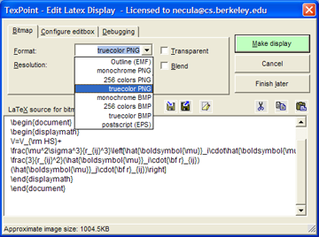
Starting in version 2.0 of TexPoint you can create displays that are not bitmaps but outline graphics format (like PDF or Postscript). The actual graphics format is called EMF (Extended Metafile). To create such a display you must make sure to have installed the "Outline displays" feature of TexPoint (available and installed unless prohibited by you, starting with version 2.0). If you have this feature installed then you will see the EMF option in the "Bitmap format" combo box when you create or edit a display
TexPoint uses the PSTOEDIT program to translate the Postscript files generated by Latex into EMF. The program pstoedit.exe is installed in the TexPoint directory.  (To see the generated EMF file you can check the "Debugging/Keep Files" box and then look into the directory that contains the presentation. You will see that these files are much smaller than the bitmap files for the same display.)
The way EMF files work is that instead of containing a bitmap rendering of the characters that make up your display they contain references to characters in True Type (.ttf) versions of the Latex fonts. The catch is that for the displays to show correctly those fonts must be installed in your system. Make sure you read how TexPoint deals with these fonts to ensure that your presentation is viewable on machines without TexPoint.
The pstoedit tool will fail to create the EMF file if it contains fonts that are not installed in the system. In that case you will see a dialog box listing the fonts that are missing. TexPoint gives you the option to let pstoedit to substitute missing fonts. Just click the "Allow font substitution" checkbox. Please let us know if this is failing for standard Tex fonts.
EMF displays are transparent by default and cannot be made otherwise.

Office 2000 users: PowerPoint 2000 "forgets" to close EMF files that it loads. This prevents TexPoint from deleting the EMF files and requires it to create new EMF files with new names. The new names are formed using the value you have in the Debugging pane (default is txp_fig) along with a random numeric suffix. It is Ok to delete these files manually after you exit PowerPoint. Their contents is already included in the presentation.


Mathtype

Equations Everywhere and Anywhere™
Work with math in over 400 applications and websites!

Install MathType 6.7 and MathType commands for Microsoft Office: the installer will automatically search  for Office installations. I tested in may 2012: it works with Microsoft office 2011 (Mac OSX 10.5.x--10.7).


Generate good-looking, accessible math web pages:
MathPage: MathType includes our MathPage™ technology that easily converts Microsoft Word documents into web pages, properly handling mathematical symbols as well as MathType and Equation Editor equations.
MathML or GIF: MathPage can generate equations as either GIF images or MathML. MathML will allow you to copy and paste math into many applications that understand MathML.
Exact Speech command: Overrides the automatically generated speech used by MathPlayer's math-to-speech or braille conversion for a selected expression or symbol. This is important in a number of situations, such as in an assessment situation where the normal speech text from screen readers or other accessible technology (AT) might give away the answer.
Math accessibility: MathML is the key to math accessibility, allowing equations in web pages to be spoken by screen readers that are used by the blind and others.

some screenshots of the files:


--------many import/export and many preferences:

the 5nd button: toggle between latex or rendering


---------
ex-ample: latex->toggle button->rendering 


---------------------------------------
http://superuser.com/questions/202806/how-to-import-latex-equation-into-ms-word-equation-or-into-mathtype


----------in french:
comment écrire un code algorithmique avec des équations dans des boites en utilisant word comme éditeur de text?


Je suis entrain d'écrire un article j'ai trouvée un problème avec latex, donc j'ai décidée d'utiliser word 2011. Le problème est que j'ai des codes algorithmiques que je vais l'introduire dans mon article, alors comment écrire un code algo en utilisant word comme éditeur de texte.


Tuesday, May 22, 2012

Spherical harmonics, meshes and some WebGL and JavaScript : toxiclibs.js, Processing.js, Three.js, ThreeNodes.js


1--------Spherical Harmonics Mesh Builder

Spherical Harmonics Mesh Builder is an example of Paul Bourke's "spherical harmonics" function for creating organic meshes. This example shows the use of Toxiclibs.js for creating meshes inside Three.js
(Technology: JavaScript, WebGL, toxiclibs.js, three.js).

Spherical harmonics are the angular portion of a set of solutions to Laplace's equation. Spherical harmonics are important in many theoretical and practical applications, particularly in the computation of atomic orbital electron configurations, representation of gravitational fields, geoids, and the magnetic fields of planetary bodies and stars, and characterization of the cosmic microwave background radiation. In 3D computer graphics, spherical harmonics play a special role in a wide variety of topics including indirect lighting (ambient occlusion, global illumination, precomputed radiance transfer, etc.) and recognition of 3D shapes.
The 19th century development of Fourier series made possible the solution of a wide variety of physical problems in rectangular domains, such as the solution of the heat equation and wave equation. This could be achieved by expansion of functions in series of trigonometric functions. Whereas the trigonometric functions in a Fourier series represent the fundamental modes of vibration in a string, the spherical harmonics represent the fundamental modes of vibration of a sphere in much the same way.
is called a spherical harmonic function of degree ℓ and order m.
For a given value of ℓ, there are 2ℓ+1 independent solutions of this form, one for each integer m with −ℓ ≤ m ≤ ℓ. 

Toxiclibs.js is an open-source computational design library ported to javascript by Kyle Phillips originally written by Karsten Schmidt for Java and Processing. Examples of the original library can be found at http://toxiclibs.org

Toxiclibs.js works great with Canvas, with SVG or any ordinary DOM element. with Processing.js, Three.js, or Raphael.js for SVG...

great example with additive waves

3--------three.js
JavaScript 3D library
The aim of the project is to create a lightweight 3D library with a very low level of complexity — in other words, for dummies. The library provides , and WebGL renderers.

--ThreeNodes.js
Threenodes.js is an attempt to create a dataflow environment in javascript and html5. It's a way to see what is possible to do in the browser. I had a little list of interesting javascript libraries to try but never had the chance to play with them.

The project is still in an experimental state but you can already see a live demo there: http://idflood.github.com/ThreeNodes.js/
coffeescript, compass and haml
These are languages that compile to javascript, css and html. Their syntax are much shorter than their equivalent and they offer some great features. If you work a lot with js, css or html you should definitely check these.
http://jashkenas.github.com/coffee-script/
http://compass-style.org/
http://haml-lang.com/
Three.js
The project is using webgl to render the scene. Three.js was obviously the 3d engine of choice. It provide many features like shaders, geometries, postprocessing filters and so on. A great project :)
https://github.com/mrdoob/three.js/
node.js
This is a javascript server. It's used to automatically compile the source files and serve them. I could have used some simple bash script to compile the files but found it would be interesting to use this for this "node" based project.
http://nodejs.org/
Require.js
The application was quickly growing and I needed a way to make it more modular. It's still not used at his full potential in threenode.js but already help make the code cleaner. One nice feature is that it's possible to require text files, or in this case little html template files.
http://requirejs.org/
--------------
Processing.js is the sister project of the popular Processing visual programming language, designed for the web. Processing.js makes your data visualizations, digital art, interactive animations, educational graphs, video games, etc. work using web standards and without any plug-ins. You write code using the Processing language, include it in your web page, and Processing.js does the rest. It's not magic, but almost.

Tuesday, September 6, 2011

PDF2SVG

PDF2SVG is an efficient, stand-alone utility for converting and publishing PDF files as web-ready SVG graphics, the open-standard W3C recommendation for high-end graphics on the web.
http://www.pdftron.com/pdf2svg/
in french: http://mscerts.programming4.us/fr/517314.aspx
PDF2SVG 3.6 

Friday, September 2, 2011

List of popular file formats and filter encoding for Map mashups and Geographic information systems; converters of waypoints, tracks, routes


Some popular file formats:

Latitude and longitude are expressed in decimal degrees using the WGS 84 datum. Elevation is recorded in meters. Dates and times are not local time, but instead are Coordinated Universal Time (UTC) using ISO 8601 format.
Find your references in any number of formats:
http://spatialreference.org/
http://spatialreference.org/ref/ it's a listing of spatial references (EPSG) and an interface to search for spatial references. EPSG codes are numeric codes associated with coordinate system definitions. For instance, EPSG:4326 is geographic WGS84.
Projections (a mathematical transformation of the surface of a sphere (3D) onto a 2D plane) are ordered roughly chronologically by type: http://www.radicalcartography.net/?projectionref
Spherical Mercator (http://en.wikipedia.org/wiki/Mercator_projection) is used to describe the PROJECTION used by many commercial API providers.
Proj4 is a library for projecting map data (used by MapServer, GDAL and a multitude of other Open Source GIS libraries): http://trac.osgeo.org/proj/

for all standards: http://www.opengeospatial.org/standards


APR – ESRI ArcView 3.3 and earlier project file
MXD – ESRI ArcGIS project file, 8.0 and higher

http://resources.arcgis.com/
http://www.arcgisblog.com/content/2010/01/arcgis-10-package-mxd-and-all-its-data-map-package

http://support.esri.com/en/downloads/samples-and-utilities/view/productid/78/metaid/1682

SHP – ESRI shapefile
http://en.wikipedia.org/wiki/Shapefile

Shapefiles spatially describe geometries: points, polylines, and polygons and associated attribute information. A shapefile is a digital vector storage format. It was introduced with ArcView GIS version 2 in the beginning of the 1990s.

DEM – USGS DEM file format:
http://en.wikipedia.org/wiki/USGS_DEM
Sources for USGS DEMs:
http://www.geobase.ca/geobase/en/data/cded/index.html Review (in english and french; download and view) a detailed description of the Canadian Digital Elevation Data. Product specifications, metadata and other supporting documentation are also available.
http://dds.cr.usgs.gov/pub/data/DEM/250/
obtain DEM’s via the National Eelevation Dataset(NED) server at: http://ned.usgs.gov

E00 – ARC/INFO interchange file format
http://freegeographytools.com/category/e00

GeoTIFF – Geographically located raster data
http://en.wikipedia.org/wiki/GeoTIFF
GeoTIFF is a public domain metadata standard which allows georeferencing information to be embedded within a TIFF file (6.0). http://trac.osgeo.org/geotiff/
World TIFF – Geographically located raster data: text file giving corner coordinate, raster cells per unit, and rotation


TAB – MapInfo Table file format
http://en.wikipedia.org/wiki/MapInfo_TAB_format
It's  a geospatial vector data format.
http://mitab.maptools.org/

DTED – Digital Terrain Elevation Data
http://en.wikipedia.org/wiki/DTED
It's a standard of digital datasets which consists of a matrix of terrain elevation values. This standard was originally developed in the 1970s to support aircraft radar simulation.
http://www.fas.org/irp/program/core/dted.htm
-----------------
-geoJSON
The GeoJSON format specification was finalized in June 2008.
http://en.wikipedia.org/wiki/GeoJSON
http://geojson.org/geojson-spec.html
GeoJSON is a geospatial data interchange format based on JavaScript Object Notation (JSON).
 In fact, every GeoJSON data structure is also a JSON object, and thus JSON tools can also be used for processing GeoJSON data.
http://www.geowebguru.com/articles/97-technical-overview-geojson
JavaScript Object Notation (JSON), and the terms object, name, value, array, and number, are defined in IETF RTC 4627, at http://www.ietf.org/rfc/rfc4627.txt
http://en.wikipedia.org/wiki/JSON
JSON is simply a mixture of JavaScript object and array literals without variable definitions.
JSON, is a text-based open standard designed for human-readable data interchange. It is derived from the JavaScript scripting language for representing simple data structures and associative arrays, called objects. Despite its relationship to JavaScript, it is language-independent, with parsers available for most languages.The JSON format is used primarily to transmit data between a server and web application (serving as an alternative to XML;  it is generally more compact than XML).

Spatial data format types supported in GeoJSON include points, polygons, multipolygons, features, geometry collections, and bounding boxes, which are stored along with feature information and attributes. The geometries and their properties will have a parent object.
GeoJSON also allows specifying a geographic coordinate system, using the OGC crs (coordinate reference system) property (preferred) or with an EPSG code. If a crs is not defined, GeoJSON will use the WGS84 geoid by default.
GeoJSON is supported by numerous mapping and GIS software packages. Google maps, google maps api...use JSON


-geoRSS
http://en.wikipedia.org/wiki/GeoRSS
http://www.georss.org/Main_Page

As RSS and Atom become more prevalent as a way to publish and share information, it becomes increasingly important that location is described in an interoperable manner so that applications can request, aggregate, share and map geographically tagged feeds.

There are currently two encodings of GeoRSS, Simple and GML (GeoRSS Geography Markup Language (GML)):
GeoRSS-Simple is meant as a very lightweight format that developers and users can quickly add to their existing feeds. It supports basic geometries (point, line, box, polygon) and covers the typical use cases when encoding locations.
GeoRSS GML is a formal GML Application Profile, and supports a greater range of features, notably coordinate reference systems other than WGS-84 latitude/longitude.
Both formats are designed for use with Atom 1.0, RSS 2.0 and RSS 1.0.


Blogger and geoRSS: http://bloggerindraft.blogspot.com/2008/12/new-feature-geotagging.html


-XML: SVG - Scalable Vector Graphics is an XML format. I think that this file format must be in this GIS list because may map servers use this format and all modern browsers use this format. 
http://www.mccurley.org/svg/
http://en.wikipedia.org/wiki/File:USA_Oregon_location_map.svg
http://commons.wikimedia.org/wiki/Category:SVG_maps
better SVG graphics rendering engine: http://antigrain.com/svg/index.html
(MapServer 5.0+ can use this engine; it supports sub-pixel anti-aliasing, as well as many more features).
look also the "svg" category of this blog ;)


-XML-based interchange format: GPX or GPS eXchange Format
GPX – XML-based interchange format
http://en.wikipedia.org/wiki/GPS_eXchange_Format
It describes waypoints, tracks, and routes. 

A collection of points (with no sequential relationship)  is deemed a collection of individual waypoints.
An ordered collection of points may be expressed as a track or a route.  Tracks are a record of where a person has been (with timestamp (because someone is recording where and when they were there)) and routes are suggestions about where you might go in the future...
View the official site: http://www.topografix.com/gpx.asp

-XML-based interchange format: KML
KML – Keyhole Markup Language, XML-based
http://en.wikipedia.org/wiki/Keyhole_Markup_Language
The KML file specifies a set of features (place marks, altitude, images, 3D models, polygons, textual descriptions, camera view...).  Each place always has a longitude and a latitude.
KML files are distributed in KMZ files, which are zipped files with a .kmz extension.
http://schemas.opengis.net/kml/2.2.0/
reference: http://code.google.com/apis/kml/documentation/kmlreference.html
Developer's Guide: http://code.google.com/apis/kml/documentation/topicsinkml.html
http://kml-samples.googlecode.com/svn/trunk/interactive/index.html


Google Maps supports the following KML elements (that is, KML queries in the Search box and GGeoXml objects in the Maps API):

  • Placemarks
  • Icons
  • Folders
  • Descriptive HTML
  • Entity replacement via and
  • KMZ (compressed KML, including attached images)
  • Polylines and polygons
  • Styles for polylines and polygons, including color, fill, and opacity
  • Network links to import data dynamically
  • Ground overlays and screen overlays

This list does not apply to Google Earth's export to Google Maps, My Maps import, or My Maps export to Google Earth.
differences between maps and earth for KML: http://code.google.com/apis/kml/documentation/kmlelementsinmaps.html


Maximum uncompressed KML file size=10MB.
Maximum number of Network Links=10.

convert GIS data to KML files
You can import GIS Data and file (ESRI Shape, MapInfo .tab data; GeoTIFF, or other raster dataset) into Google Earth Pro so that it can be used as part of your Google Earth visualizations: http://earth.google.com/outreach/tutorial_importgis.html. If you have Google Earth Pro, you can import many kinds of GIS data directly using the methods described in this tutorial. If you are using the free version of Google Earth, there are other tools for converting GIS data to KML.


ESRI ArcGIS and MapInfo, have tools to export GIS data into KML format (for use in Google Earth).

ogr2gui (http://sourceforge.net/projects/ogr2gui/): a free utility that converts many formats, including shapefiles to KML.
shp2kml (http://www.zonums.com/shp2kml.html): a free utility that converts shapefiles to KML.
MapWindow GIS has Shape2Earth (http://shape2earth.com/default.aspx), a tool for converting GIS data to KML.
ESRI ArcGIS contains tools in the ArcToolbox (Conversion Tools > To KML) for converting vector and raster GIS data to KML.
Arc2Earth (http://www.arc2earth.com/) is an extension for ArcGIS that converts GIS data to KML. The Arc2Earth Community Edition (http://www.arc2earth.com/communityedition/) is a free tool that has lower limits than the full version.
MapInfo Professional has a MapInfo Professional Google Earth Link Utility: http://mapinfo-to-google-earth-tm-export-utilit.software.informer.com/


KML and Spreadsheet Mapper
How to enter data in an on-line spreadsheet to generate a set of placemarks in Google Earth and Maps. Google Docs' web-based, collaborative editing allows your team members to simultaneously enter data and instantly publish updates:
http://earth.google.com/outreach/tutorial_spreadsheet.html

KML and Fusion Table
Because Fusion Tables also supports visualizing your data on maps, it is an alternative to Spreadsheet Mapper: http://earth.google.com/outreach/tutorial_fusion_sample.html
http://earth.google.com/outreach/tutorial_fusion_yourowndata.html#comparemappers
Biking and Hiking trails from MTBGuru.com:
http://blog.mtbguru.com/2010/02/24/mtbguru-tracks-as-seen-through-google-fusion-tables/

a scientific paper: Hector Gonzalez, Alon Halevy, Christian S. Jensen, Anno Langen, Jayant Madhavan, Rebecca Shapley, Warren Shen (2010). "Google Fusion Tables: Data Management, Integration and Collaboration in the Cloud". SoCC'10. ACM:
http://www.cse.ohio-state.edu/~agrawal/788-au10/Papers/Oct28/google-fusion-socc10.pdf

Fusion Tables supports a number of data formats:
Comma-separated files (.csv) - Up to 100 MB
Microsoft Excel files (.xls, .xlsx) - Up to 1 MB
OpenDocument Spreadsheet (.ods) - Up to 1 MB
Keyhole Markup Language (.kml) - Up to 100 MB
Data already in a Google Spreadsheet
If you have datasets in Excel or Open Office Spreadsheets that are larger than 1MB, save them as CSV files to take advantage of the larger 100MB limit!

Manage your Data with Open Data Kit Aggregate:
http://earth.google.com/outreach/tutorial_odk_aggregate.html
Open Data Kit (ODK) is a suite of tools that allows data collection using mobile devices and data submission to an online server, even without an Internet connection or mobile carrier service at the time of data collection. Once you've collected data in the field with ODK Collect, you can upload and manage your data using ODK Aggregate. ODK Aggregate is the intermediary server storage platform that accepts the data and can send it on to external applications, if desired. ODK Aggregate also allows you to download your datasets in aggregated formats, such as one .csv file. ODK Aggregate allows you to use Google's AppEngine hosting platform (see many post of this blog) for managing your collected data online.

------------other links:
http://en.wikipedia.org/wiki/Geography_Markup_Language (GML)
http://en.wikipedia.org/wiki/GIS_file_formats

------------freeware and set of library (converters; filters)
"data conversion" database:
http://freegis.org/database/?cat=11
"geodata" database:
http://freegis.org/database/?cat=1


MapTools Packaged Tools and Utilities:
http://maptools.org/


a list of bookmarks:
http://www.spatialhydrology.com/freedownload.html


------GDAL
GDAL (Geospatial Data Abstraction Library) is a multi-format raster reading and writing library (it is used as the primary mechanism for reading raster data in MapServer).
It provides a powerful set of libraries for working with vector data:
http://trac.osgeo.org/gdal/
http://code.google.com/apis/kml/articles/vector.html
http://trac.osgeo.org/gdal/wiki/DownloadingGdalBinaries


------GPSBabel
GPSBabel converts waypoints, tracks, and routes between popular GPS receivers and mapping programs. It also has powerful manipulation tools for such data.
It contains extensive data manipulation abilities making it a convenient for server-side processing or as the backend for other tools. It does not convert, transfer, send, or manipulate maps. It processes data that may placed on a map, such as waypoints, tracks, and routes...
GPSBabel runs on Microsoft Windows 95, 98, ME, 2000, XP, and Vista plus POSIX OSes such as Linux, UnixWare, OpenServer, Solaris, FreeBSD, and OSX.

File FormatWaypointsTracksRoutes

ReadWriteReadWriteReadWrite
Alan Map500 tracklogs (.trl)
alantrl
yesyes
Alan Map500 waypoints and routes (.wpr)
alanwpr
yesyesyesyes
Brauniger IQ Series Barograph Download
baroiq
yes
Bushnell GPS Trail file
bushnell_trl
yesyes
Bushnell GPS Waypoint file
bushnell
yesyes
Cambridge/Winpilot glider software
cambridge
yesyes
CarteSurTable data file
cst
yesyesyes
Cetus for Palm/OS
cetus
yesyesyes
CoastalExplorer XML
coastexp
yesyesyesyes
Columbus/Visiontac V900 files (.csv)
v900
yesyes
Comma separated values
csv
yesyes
CompeGPS data files (.wpt/.trk/.rte)
compegps
yesyesyesyesyesyes
CoPilot Flight Planner for Palm/OS
copilot
yesyes
cotoGPS for Palm/OS
coto
yesyesyes
Data Logger iBlue747 csv
iblue747
yesyes
Dell Axim Navigation System (.gpb) file format
axim_gpb
yes
DeLorme .an1 (drawing) file
an1
yesyesyesyesyes
DeLorme GPL
gpl
yesyes
DeLorme PN-20/PN-30/PN-40 USB protocol
delbin
yesyesyesyesyesyes
DeLorme Street Atlas Plus
saplus
yesyes
DeLorme Street Atlas Route
saroute
yes
DeLorme XMap HH Native .WPT
xmap
yesyes
DeLorme XMap/SAHH 2006 Native .TXT
xmap2006
yesyes
DeLorme XMat HH Street Atlas USA .WPT (PPC)
xmapwpt
yesyes
Destinator Itineraries (.dat)
destinator_itn
yesyes
Destinator Points of Interest (.dat)
destinator_poi
yesyes
Destinator TrackLogs (.dat)
destinator_trl
yesyes
EasyGPS binary format
easygps
yesyes
Embedded Exif-GPS data (.jpg)
exif
yesyes
Enigma binary waypoint file (.ert)
enigma
yesyesyesyes
FAI/IGC Flight Recorder Data Format
igc
yesyesyesyes
Franson GPSGate Simulation
gpssim
yesyesyes
Fugawi
fugawi
yesyes
G7ToWin data files (.g7t)
g7towin
yesyesyes
Garmin 301 Custom position and heartrate
garmin301
yesyes
Garmin Logbook XML
glogbook
yesyes
Garmin MapSource - gdb
gdb
yesyesyesyesyesyes
Garmin MapSource - mps
mapsource
yesyesyesyesyesyes
Garmin MapSource - txt (tab delimited)
garmin_txt
yesyesyesyesyesyes
Garmin PCX5
pcx
yesyesyesyesyesyes
Garmin POI database
garmin_poi
yesyes
Garmin Points of Interest (.gpi)
garmin_gpi
yesyes
Garmin serial/USB protocol
garmin
yesyesyesyesyesyes
Garmin Training Center (.tcx)
gtrnctr
yesyesyes
Geocaching.com .loc
geo
yesyes
GeocachingDB for Palm/OS
gcdb
yesyes
Geogrid-Viewer ascii overlay file (.ovl)
ggv_ovl
yesyesyesyesyesyes
Geogrid-Viewer tracklogs (.log)
ggv_log
yesyes
GEOnet Names Server (GNS)
geonet
yesyes
GeoNiche .pdb
geoniche
yesyes
GlobalSat DG-100/BT-335 Download
dg-100
yes
Google Earth (Keyhole) Markup Language
kml
yesyesyesyesyesyes
Google Maps XML
google
yes
Google Navigator Tracklines (.trl)
gnav_trl
yesyes
GoPal GPS track log (.trk)
gopal
yesyes
GpilotS
gpilots
yesyes
GPS TrackMaker
gtm
yesyesyesyesyesyes
GPSBabel arc filter file
arc
yesyes
GpsDrive Format
gpsdrive
yesyes
GpsDrive Format for Tracks
gpsdrivetrack
yesyes
GPSman
gpsman
yesyes
GPSPilot Tracker for Palm/OS
gpspilot
yesyes
gpsutil
gpsutil
yesyes
GPX XML
gpx
yesyesyesyesyesyes
HikeTech
hiketech
yesyesyesyes
Holux (gm-100) .wpo Format
holux
yesyes
Holux M-241 (MTK based) Binary File Format
m241-bin
yes
Holux M-241 (MTK based) download
m241
yes
Honda/Acura Navigation System VP Log File Format
vpl
yes
HSA Endeavour Navigator export File
hsandv
yesyes
HTML Output
html
yes
Humminbird tracks (.ht)
humminbird_ht
yesyesyesyes
Humminbird waypoints and routes (.hwr)
humminbird
yesyesyesyesyes
IGN Rando track files
ignrando
yesyes
iGO2008 points of interest (.upoi)
igo2008_poi
yesyes
IGO8 .trk
igo8
yesyes
Jelbert GeoTagger data file
jtr
yesyes
Jogmap.de XML format
jogmap
yes
Kartex 5 Track File
ktf2
yesyes
Kartex 5 Waypoint File
kwf2
yesyes
Kompass (DAV) Track (.tk)
kompass_tk
yesyes
Kompass (DAV) Waypoints (.wp)
kompass_wp
yesyes
KuDaTa PsiTrex text
psitrex
yesyesyesyesyesyes
Lowrance USR
lowranceusr
yesyesyesyesyesyes
Magellan Explorist Geocaching
maggeo
yesyes
Magellan Mapsend
mapsend
yesyesyesyesyesyes
Magellan NAV Companion for Palm/OS
magnav
yesyes
Magellan SD files (as for eXplorist)
magellanx
yesyesyesyesyesyes
Magellan SD files (as for Meridian)
magellan
yesyesyesyesyesyes
Magellan serial protocol
magellan
yesyesyesyesyesyes
MagicMaps IK3D project file (.ikt)
ik3d
yesyes
Map&Guide 'TourExchangeFormat' XML
tef
yes
Map&Guide to Palm/OS exported files (.pdb)
mag_pdb
yesyes
MapAsia track file (.tr7)
mapasia_tr7
yesyes
Mapopolis.com Mapconverter CSV
mapconverter
yesyes
MapTech Exchange Format
mxf
yesyes
Memory-Map Navigator overlay files (.mmo)
mmo
yesyesyesyesyesyes
Microsoft AutoRoute 2002 (pin/route reader)
msroute
yes
Microsoft Streets and Trips (pin/route reader)
msroute
yes
Microsoft Streets and Trips 2002-2007
s_and_t
yesyes
Motorrad Routenplaner (Map&Guide) .bcr files
bcr
yesyes
MS PocketStreets 2002 Pushpin
psp
yesyes
MTK Logger (iBlue 747,...) Binary File Format
mtk-bin
yes
MTK Logger (iBlue 747,Qstarz BT-1000,...) download
mtk
yes
National Geographic Topo .tpg (waypoints)
tpg
yesyes
National Geographic Topo 2.x .tpo
tpo2
yes
National Geographic Topo 3.x/4.x .tpo
tpo3
yesyesyes
Navicache.com XML
navicache
yes
Navigon Mobile Navigator .rte files
nmn4
yesyes
Navigon Waypoints
navigonwpt
yesyes
NaviGPS GT-11/BGT-11 Download
navilink
yesyesyesyesyesyes
NaviGPS GT-31/BGT-31 datalogger (.sbp)
sbp
yes
NaviGPS GT-31/BGT-31 SiRF binary logfile (.sbn)
sbn
yes
Naviguide binary route file (.twl)
naviguide
yesyes
Navitel binary track (.bin)
navitel_trk
yesyes
Navitrak DNA marker format
dna
yesyes
NetStumbler Summary File (text)
netstumbler
yes
NIMA/GNIS Geographic Names File
nima
yesyes
NMEA 0183 sentences
nmea
yesyesyesyes
Nokia Landmark Exchange
lmx
yesyes
OpenStreetMap data files
osm
yesyesyesyesyes
OziExplorer
ozi
yesyesyesyesyesyes
PalmDoc Output
palmdoc
yes
PathAway Database for Palm/OS
pathaway
yesyesyesyesyesyes
PocketFMS breadcrumbs
pocketfms_bc
yesyes
PocketFMS flightplan (.xml)
pocketfms_fp
yesyes
PocketFMS waypoints (.txt)
pocketfms_wp
yesyes
Quovadis
quovadis
yesyes
Raymarine Waypoint File (.rwf)
raymarine
yesyesyesyes
Ricoh GPS Log File
ricoh
yesyes
See You flight analysis data
cup
yesyes
Skymap / KMD150 ascii files
skyforce
yesyesyesyesyesyes
SkyTraq Venus based loggers (download)
skytraq
yesyes
SkyTraq Venus based loggers Binary File Format
skytraq-bin
yesyes
Sportsim track files (part of zipped .ssz files)
sportsim
yesyes
Suunto Trek Manager (STM) .sdf files
stmsdf
yesyesyesyes
Suunto Trek Manager (STM) WaypointPlus files
stmwpp
yesyesyesyesyesyes
Swiss Map 25/50/100 (.xol)
xol
yesyesyesyes
Tab delimited fields useful for OpenOffice, Ploticus etc.
openoffice
yesyes
Teletype [ Get Jonathon Johnson to describe
teletype
yesyes
Textual Output
text
yes
TomTom Itineraries (.itn)
tomtom_itn
yesyes
TomTom Places Itineraries (.itn)
tomtom_itn_places
yesyes
TomTom POI file (.asc)
tomtom_asc
yesyes
TomTom POI file (.ov2)
tomtom
yesyes
TopoMapPro Places File
tmpro
yesyes
TrackLogs digital mapping (.trl)
dmtlog
yesyesyesyes
U.S. Census Bureau Tiger Mapping Service
tiger
yesyes
Universal csv with field structure in first line
unicsv
yesyesyesyesyesyes
Vcard Output (for iPod)
vcard
yes
VidaOne GPS for Pocket PC (.gpb)
vidaone
yesyes
Vito Navigator II tracks
vitosmt
yesyesyesyesyesyes
Vito SmartMap tracks (.vtt)
vitovtt
yes
WiFiFoFum 2.0 for PocketPC XML
wfff
yes
Wintec TES file
wintec_tes
yesyes
Wintec WBT-100/200 Binary File Format
wbt-bin
yes
Wintec WBT-100/200 GPS Download
wbt
yesyes
Wintec WBT-201/G-Rays 2 Binary File Format
wbt-tk1
yes
XAiOX iTrackU Logger
itracku
yesyes
XAiOX iTrackU Logger Binary File Format
itracku-bin
yesyesyesyes
Yahoo Geocode API data
yahoo
yes


Filter Encoding is an OGC standard which defines an XML encoding for filter expressions to allow for spatial and attribute querying: http://www.opengeospatial.org/standards/filter

some filters:


Filter FunctionFilter NameWaypointsTracksRoutes
Points along an arcarcyes

Remove unreliable points with high hdop or vdopdiscard
yes
Remove duplicatesduplicateyes

Manipulate altitudesheightyes

Interpolate between trackpointsinterpolateyes

Remove waypoints, tracks, or routes from processing.nuketypes
yes
Remove points around polygonpolygonyes

Remove points within relative distancepositionyes

Include only points within radiusradiusyes

Reverse a pathreverse
yesyes
Simplify routessimplify
yesyes
Stack operationsstackyesnono
Sort waypointssortyes

Manipulate track liststrack
yes
Transform waypoints, tracks, routes into each othertransformyesyesyes